
 
Помощь сайту | Donate
 WMZ: 826074280762 WME: 804621616710 WMZ: 826074280762 WME: 804621616710
 4100117770549562
 Поиск по сайту
Вход на сайт
Меню
    Форум NoWa.cc На главную • Программы • Релизы • Наборы AIO • ОС • Мобила • Игры • Видео • Музыка • Книги • Аудиокниги • Оформление • Photoshop • Юмор • Новости • Железо • Разное Форум NoWa.cc На главную • Программы • Релизы • Наборы AIO • ОС • Мобила • Игры • Видео • Музыка • Книги • Аудиокниги • Оформление • Photoshop • Юмор • Новости • Железо • РазноеПоследние комментарии
09:46 | diim 18:57 | diim 16:19 | Assur 15:58 | Pepa112 21:17 | Trashman 12:57 | mxhxbug 07:20 | Haul2006 19:15 | Carhel 16:53 | mrjok 09:17 | m4657 03:20 | Haul2006 16:36 | eduard33 14:52 | tinbin 08:05 | m4657 17:32 | marlon 16:13 | tinbin 13:31 | rory13 13:48 | marlon 12:10 | l0kid 14:38 | gofraЗаказ рeклaмы
Купите у нас рекламу ! Your advertising could be here ! E-mail для связи: 
Партнёры
Для вас работают
 diim (админ) brodyga (админ) marlon leteha Ledworld Mansory1 Masarat manivell17 Sanchezzz sibius777 Sergv diim (админ) brodyga (админ) marlon leteha Ledworld Mansory1 Masarat manivell17 Sanchezzz sibius777 Sergv |
  Новость от: marlon
Просмотров: 549
Компания Avenza Systems, разработчик системы подготовки ГИС карт к изданию (MAPublisher) в среде Adobe Illustrator and Macromedia FreeHand, а также баз данных MAPdataUSA и MAPdataWorld, объявила о выпуске расширения Geographic Imager, которое призвано дополнить эту мощную графическую систему возможностями работы с геопространственными данными. Новое расширение содержит новые инструментальные средства для поддержки импорта/экспорта ГИС-данных, аэрокосмических снимков и их редактирования, что позволит полностью использовать все функциональные возможности Photoshop для работы с графикой. С помощью Geographic Imager в среде Adobe Photoshop станут доступны операции с geotiffs и другими форматами географически привязанных изображений, автоматическое составление мозаик, преобразования в другие проекции на основе опорных точек.
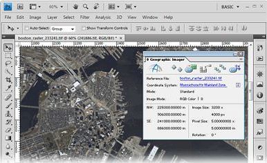 Working with raster imagery doesn't have to be complicated. Geographic Imager® enhances the Adobe Photoshop imaging environment to make working with spatial imagery quick and efficient. It adds tools to import, edit, manipulate and export of geospatial images such as aerial and satellite imagery. Enjoy the use of native Adobe Photoshop functions such as transparencies, filters, pixel editing, and image adjustments like brightness, contrast, and curve controls while maintaining spatial referencing. Geographic Imager supports GeoTIFF in Adobe Photoshop and other industry standard raster formats, mosaics and tiles images, changes projections, and transforms and georeferences images based on ground control points. Geographic Imager is a great companion to MAPublisher for Adobe Illustrator—prepare images in Geographic Imager and use MAPublisher to directly import them. Transform Extensive support for thousands of geographic and projected coordinate systems. Easily transform between geodetic and projected coordinate systems. Need to define your own coordinate system? Create one or edit an existing definition and save it for future use. Manage custom transformations in an easy to use coordinate system browser. Georeference Georeference images easily by adding ground control points. Manually add control points, import or export points from a text file, and view accuracy and errors. Use the Quick Georeference option to make georeferencing even easier. Multiple transformation types are supported. Mosaic Snapping images together not working? Mosaic individual images to create a seamless image. Retain images as separate layers or flatten to create one image. Images mosaicked together retain spatial referencing and can be individually modified using Adobe Photoshop tools or transformed using Geographic Imager. Tile Forget the Slice tool. Tile an image into multiple images by tile size or count and automatically save them using sequential naming. Tiles retain spatial referencing making it ideal to import into MAPublisher without any trouble. Geographic Imager 3.0 features and additions 64-bit support - Geographic Imager is now supported on Adobe Photoshop CS4 64-bit for Windows XP/Vista/7. Open larger images and greatly improve Adobe Photoshop and Geographic Imager performance. New supported image formats - Several new formats are supported: BIL, NITF and BigTIFF. See all Geographic Imager supported formats. Georeference - Several enhancements were made to the Georeference tool. The ground control points can now be specified in their own coordinate system within the Georeference dialog box. The Quick Georeference functions has an additional option to load the reference of another file. New customizing options have been introduced such as control point and label colours. A tool to remove georeference has been added GeoCrop - New and improved GeoCrop and GeoCrop Import user interface. It now includes a crop image preview. Draw a crop marquee, use point proximity or specify pixel, geodetic or projected coordinates or to define a crop area quickly and easily. Digital Elevation Model (DEM) Schema - DEMs provide an effective method of storing information for a continuous surface. DEM data needs to be rendered, so it can be displayed visually. Depending on what type of DEM data it is and how it should look, the type of rendering schema needs to be customized or automatically assigned. Tiled images can now be saved to any image formats supported by Adobe Photoshop Automating tasks - All functions provided by Geographic Imager are now fully compatible with scripts and actions, and can be scripted or recorded to easily automate repetitive tasks. Licence management - New licensing management system. Easily manage license options including commercial, academic, multi-user and floating. Various other user interface improvements and performance enhancements to improve usability. What's new in Geographic Imager 3.4? Fully compatible with Adobe Photoshop CS5.1 (also known as Photoshop 12.1 in Adobe CS5.5) in both 32 and 64 bit New import support for ERDAS IMAGINE (.img), Esri ArcInfo Binary Float Grid (.flt), and "DEM" grayscale GeoTIFF (*.tif) formats, including ability to import georeferenced images from Web Map Service (WMS) sources New export support for BigTIFF, ECW (up to 0.5 GB), and NITF formats Major enhancements to Advanced Import, including options to: import multiple files of differing formats resample and crop images prior to import modify bands/channel color mapping and select specific channels to import for multiband/hyperband images mosaic and import images as layers into existing documents specify and adjust DEM and DTM information and combine multiple DEM files on import Enhanced Quick Save feature for quick format conversion New ability to measure areas in images using the Adobe Photoshop Measurement Log panel Various bug fixes and user experience enhancements Официальный сайт | Home Page www.avenza.com Размер | Size: 262.6 MB  Avenza.Geographic.Imager.for.Adobe.Photoshop.v6.2-AMPED Зеркало/Mirror - Uploaded.net Зеркало/Mirror - NitroFlare.com Зеркало/Mirror - RapidGator.net Пароль/Password: www.2baksa.net
Раздел: Программы | 22.10.20 | 21:32
|
|||||||||

|
Design by DolpHin | Disclaimer Реклама | E-mail для связи: |
Skype: diim_diim | ICQ: 400632 |
|

 Внимание! Всегда проверяйте анти-вирусом файлы, полученные по ссылкам в комментариях!Attention! Always check files you download from links in comments with your anti-virus software!