Global Mapper Pro 26.2.1 Build 110625
Global Mapper Pro expands upon the extensive functionality of the standard version of the application for those with advanced workflows. You can utilize a comprehensive collection of tools for advanced 3D analysis, lidar and photogrammetric point cloud processing, drone-collected image analysis, Python scripting methods, machine-learning integration and much more.
Languages: English | File Size: 522 MB
Global Mapper Pro расширяет расширенные функциональные возможности стандартной версии приложения для тех, у кого расширенные рабочие процессы. Вы можете использовать обширную коллекцию инструментов для расширенного 3D-анализа, лидарной и фотограмметрической обработки облаков точек, анализа изображений, полученных с помощью дронов, методов написания сценариев Python, интеграции машинного обучения и многого другого.
The comparison chart below shows the features and tools available in the Standard and Pro versions of Global Mapper.
PLEASE NOTE: Global Mapper Pro is an add-on to the Global Mapper Standard application. When purchasing Global Mapper Pro, you will receive two licenses—one for Global Mapper Standard and one for Global Mapper Pro. You must install both licenses to unlock the Pro features.
Recent Developments in Global Mapper Pro
The Global Mapper Insight and Learning Engine (beta) - Powerful deep-learning image analysis tools for land cover classification and object detection with vehicle detection fine-tuning and custom model sharing.
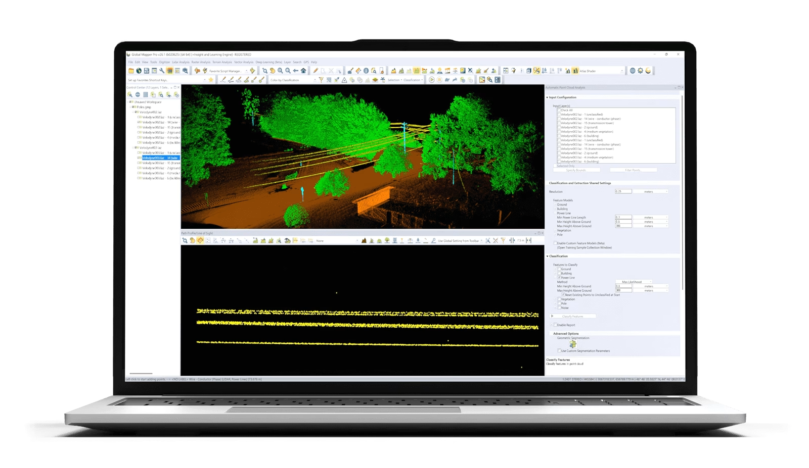
Point Cloud Classification Improvements - Updates to streamline the manual classification workflow. Addition of segmentation-based classification method for powerlines improves the accuracy and efficiency of point cloud processing.
Split Point Cloud by Attribute - Separate point clouds into layers based on classification, point source ID, or return number
Scripting Toolbar - Favorite Python and Global Mapper scripts can be saved for easy access and execution.
Deep-learning Powered Image Analysis with Global Mapper Insight and Learning Engine (beta)
The deep-learning image analysis tools in the Insight and Learning Engine provide built in models for land cover classification, building extraction, and vehicle detection. Utilize the fine-tuning and training tools to tailor the models to improve model performance on your own datasets. Configuration settings allow users to share custom models, and download the latest models from Blue Marble Geographics.
Photogrammetric Processing with Pixels to Points
Create a 3D point cloud, orthoimage, and 3D mesh products from drone or UAV collected images utilizing Pixels to Points in Global Mapper Pro. The Pixels to Points Wizard allows users to select from predefined project types and optional outputs, or create their own. Leverage the ability to automatically place GCPs to further control output product accuracy.
Lidar Data Analysis
Global Mapper Pro offers the opportunity to fully classify 3D point cloud data. Automatic ground, building, tree, powerline, and pole classification and feature extraction tools work with lidar or photogrammetrically-generated point cloud data. Utilize manual classification options for more precise control.
With various selection methods available in 2D, 3D, and the Path Profile views, point return classes, elevation, and attributes can be altered. Additional Lidar QC tools to enhance the 3D position of point clouds through manual rectification or base on control points or overlapping point clouds provide a set of tools suited for all lidar data processing.
Point Cloud Segmentation by Spectral Graph Partitioning
This tool allows users to identfiy features of interest in a point cloud based on certain parameters or attributes. Whether color, elevation, intenstiy, or another parameter is important in defining a feautre, users can provide values to allow the tool to identify points which meet these requirements. The flexibility and customization in this tool, combined with a selection method to select and edit individual segments, greatly improves manual classification, to achieve custom point cloud classification in a semi-automated process.
Terrain Analysis
Global Mapper Pro has an array of terrain analysis tools. From advanced binning and kriging methods to create a surface, to terrain painting to live edit the terrain users can prepare their data a variety of ways. The reults of this process can be analysed via watershed modelling, viewshed analysis, contour generation or a slew of other tools available in Global Mapper and Global Mapper Pro
Mesh Feature Creation
Create 3D mesh products from a variety of terrain, point clouds, and 3D vector data. Volumetric mesh features can also be created as spheres and cylinders to more effectively model volume in a variety of workflows. Export these products to a variety of 3D formats to use in gaming engines, simulated environments, and more.
Home Page - https://www.bluemarblegeo.com/global-mapper-pro/
Download from file storage
Global Mapper Pro 26.2.1 Build 110625 + crack-Xray
News article is edited by: 2baksa - 10-11-2025, 08:12
Reason: new version
Users of Guests are not allowed to comment this publication.